
The Geological History of Saddleworth, West Yorkshire
Educational History - from GCSE's to Climate REsearch & Science Education
The Ellisons are a family of educators and Geology enthusiasts. Father ( Bill Ellison - Teacher Mossley Hollins), Mother (Liz Ellison - Teacher of SEND), Uncle ( Primary - Dukinfield ), Brother (Paul - Geography at Bangor University) and niece ( Hannah - Teacher of Maths) all loved learning and sharing knowledge. This webpage was originally written as an inspired Geology student when I was just 20 years of age (see above enjoying the Dish Stone above Dovestones Reservoir and nostalgic hand-drawn diagrams throughout ! ). As a second year undergraduate at the time at UEA ( Norwich ), I was drawn to the department for their Climate Research Unit (CRU). It was there that I discovered a passion for the Geological and Earth Sciences which inspired this guide to educate visitors in the local area to add even more appeal to the already inspiring environment in the Saddleworth district by explaining its complex geological history. I came to realise that Saddleworth actually displays some exquisite sedimentological characteristics and these are quite easily observed all over the area.
Solid Geology
The details that follow focus on what is known as the ‘solid geology’ of the area which basically incorporates the true hard rocks which dominate the landscape. In the future, I hope to add details of the ‘drift geology’ deposited during the more recent ice ages over the last 2.5 Million years in a period known as the Quaternary.
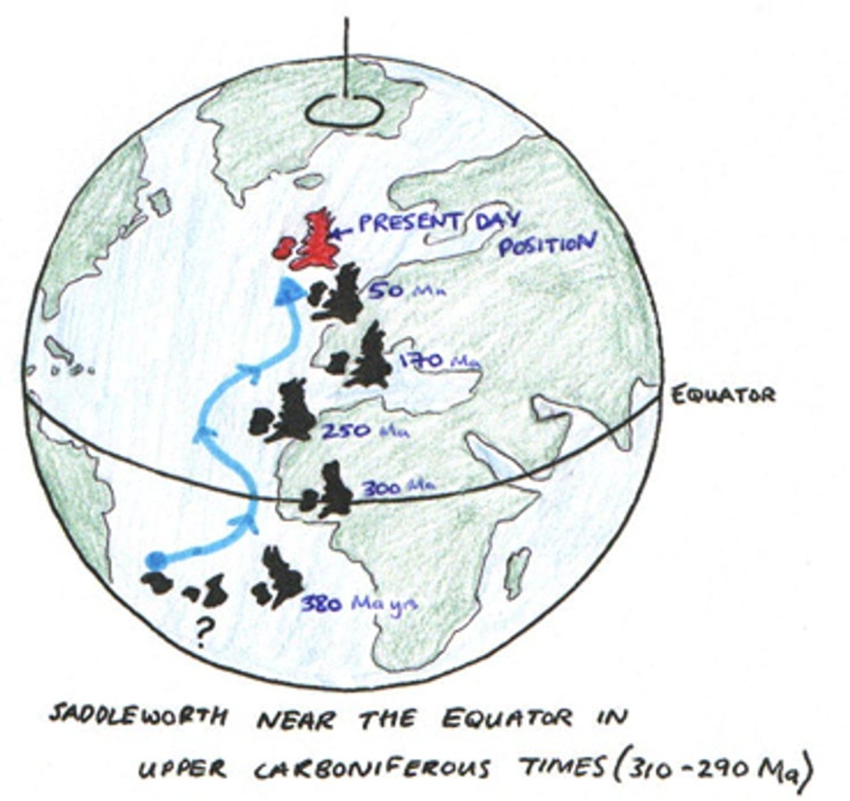
Tropical Climates of the PAst - HuGE equatorial RIVERS
Yorkshire in the Carboniferous
The origin of these geological facies lies in the Carboniferous period which spans from 355-290 Million years ago. More specifically, the Saddleworth region reveals sediments of Upper Carboniferous age and therefore date between 310-290 Million (Ma) yrs before present (BP). At this time, Saddleworth (and indeed the British Isles) had a very different climate as a result ofits dramatically different position on earth. Magnetic analysis of the geological rock record has revealed an apparent ‘polar wandering’ where it is clear that the British Isles have gradually moved from the southern hemisphere to our present latitude in the sub-polar northern hemisphere ( See Above - rocks analysed for their magnetic signatures reveal they were formed near the equator and plate tectonics slowly push the UK northwards to its present day position)
Evidence all around us
The rocks exposed in the Saddleworth region reveal a fascinating history of how the land around us was formed. The typical rocks exposed here are commonly known as ‘Millstone Grit’ due to their coarse sandstone texture. These feldspar and quartz rich deposits are dominant but are associated with siltstones, mudstones, marine shales and coal deposits which can also be seen in the area. This rock group has an average thickness of around 2000m.
Ancient Depositional Environments in the Carboniferous
UK - Carboniferous Rivers
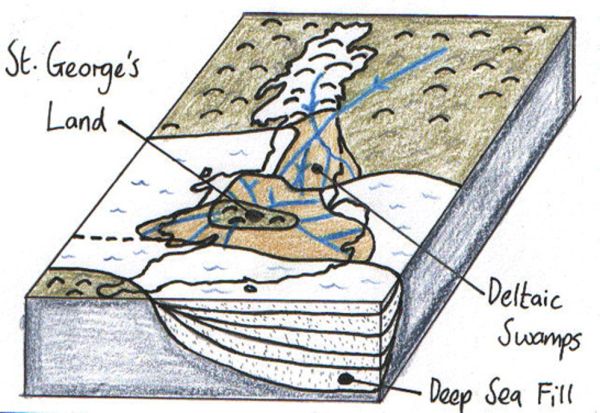
Distinctive minerals in the Millsone grits can be traced from the highlands of Scotland and Norway, therefore deducing drainage from the north. As well as from the north, deltas also advanced from the southwest from a past island known as ‘St. George’s land’. Temporary readvances of the sea are indicated by the presence of fossil Goniatites which is a type of shallow marine cephalopod.
DELTA Sediment Deposition

At the time of Saddleworth’s formation, the UK was experiencing equatorial environments, including tropical deltas and low lying swamps. The organic material in the swamp environments lead to the large coal formations extensive in Yorkshire and the ancient deltas are essentially what are exposed in Saddleworth.

Evidence of Ancient River Flow Directions in Saddleworth
The photograph and figures above explain the development of the cross-bedding seen in the rocks around Dovestone Reservoir and can be mapped all across Yorkshire.
Observing these features in Saddleworth is relatively easy once one knows the basic form of evidence to look for. The growth of a delta front is created by the continuous deposition of sediment from a landmass onto the submarine slope. A modern analogue would be the Egyptian River Nile delta or the delta on the River Ganges, Bangladesh. Outflow from a river gives the shallow waters a uni-directional current flow and typically beds (or layers) of sediment drape over each other as they accumulate.
River Deposition
These deltaic flow directions and sediment accumulation patterns can be seen in the photographs which were taken around the Dovestones Reservoir region. Flow can be deduced as from left to right as classic ‘S’ curve prograding bed features can be seen. Also evident from this photograph is the evolution of the past submarine slope deposits with the upward variation in bed thickness (7 beds in all with 3 thinner strata at hammer-head level).
Spatial Variation of Rock Types and Local Evidence
Cyclic Rock Sequences
RIPPLES - Diggle Quarries
RIPPLES - Diggle Quarries
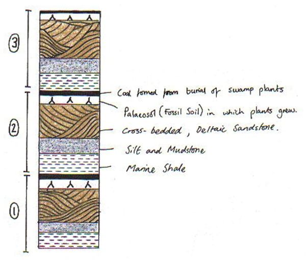
In any delta, changes in the depth of water, variations in the rate or nature of sediment supply and alterations in the strength and direction of water currents are reflected in the character of the sediment laid down. If these factors change gradually, there should be a vertical transition from one rock type to another ( a relationship with depth mainly). The further out to sea, lighter (finer grained) sediment will be deposited due to the lower energy away from the dynamic river. Similarly, coarse grained sands are closer to the land as they are heavier and sink in higher energy environments. As this process continues and the delta front grows, it is logical to see that fine sediment deposited further out to sea will gradually be covered by coarser material. Generally then, we have a cycle which coarsens as we travel up the sequence. This assumes no tectonic or sea level change factors which would influence the deposition style. The cycle model can be seen above showing brown deltaic sandstones ( Millstone Grit ) sequenced with coal seams & marine shales.
RIPPLES - Diggle Quarries
RIPPLES - Diggle Quarries
RIPPLES - Diggle Quarries

This close up of the rock surface shows ancient ripple surfaces similar to those you may see on a beach when the tide is out. This once again confirms Saddleworth's marine origins and we are lucky that these detailed features have been preserved in the rock record. Examples of Ripples can be seen on exposed beds around the local area, especially around the Marsden exposures at Pule Hill.
Welcome! Happy to help you discuss your needs in a quick call - click the button below and enjoy the website !